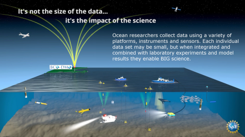
Resources
How to Contribute Data
This section describes the process for contributing data from NSF OCE funded projects to the BCO-DMO data system. If you would like to discuss management of data associated with an existing or proposed project, please contact us. For funded projects, please be prepared to provide your NSF OCE award number.
BCO-DMO staff members work with researchers funded by NSF OCE to ensure that data and metadata contributed to BCO-DMO are in compliance with the current NSF OCE Sample and Data Policy (May 2011 version).
To start the process, forms are available for contributing program, project, deployment, and dataset metadata to the BCO-DMO. The Program Form is used to describe large coordinated research programs that are not already registered at BCO-DMO. Projects are smaller than Programs, most often one per NSF award. The forms are Rich Text Format files that are compatible with any Word Processing application.
- Program metadata (Program Form)
- Project metadata (Project Form)
- Deployment (e.g. cruise) metadata (Deployment Form)
- Dataset metadata (Dataset Form)
Most data sets can be contributed as email attachments along with their respective completed DATASET metadata form. We accept data in any format, but comma or tab-delimited (preferred) or Excel spreadsheets are most common. If the data set is too large to contribute as an email attachment, please contact our office for instructions on the best way to contribute your data.
After the data are online and fully documented, our office will ensure that the data are archived properly at the appropriate National Data Center (e.g. NODC). A separate document lists the National Data Centers where data managed by BCO-DMO are sent for long-term archive (see where to archive data).
A full description of BCO-DMO is available in a PDF document (download PDF).
OCB research community: A series of 'milepost' documents providing guidance to OCB scientists who are uncertain where to submit or propose to submit their data is being drafted.
- NSF-OCE and NASA OB&B biogeochemical data submission milepost (view the PDF)
NSF Two Page Data Management Plan
[posted January 2011] Proposals submitted to NSF and due on or after January 18, 2011, must include a supplementary document of no more than two pages labeled "Data Management Plan" (hereafter referred to as ‘the two page plan’). This supplementary document (a supplement to the 15 page proposal) should describe how the proposal will conform to NSF policy on the dissemination and sharing of research results. See the full description in the Grant Proposal Guide (GPG) Chapter II.C.2.j for full policy implementation (http://www.nsf.gov/pubs/policydocs/pappguide/nsf11001/gpg_2.jsp#dmp).
If the proposal is being submitted to NSF Geosciences Directorate (GEO) Division of Ocean Sciences (OCE) Biological or Chemical Oceanography Sections or Office of Polar Programs (OPP) Antarctic Sciences (ANT) Organisms & Ecosystems Program then the two-page plan can state that BCO-DMO staff will work with you to manage the data, and that data or model results generated during the proposed research project will be contributed to the BCO-DMO system.
The BCO-DMO has prepared a document that includes recommendations and a suggested outline for the two page plan for an NSF OCE proposal involving a research cruise and data management being done in partnership with BCO-DMO staff. However, these recommendations could be modified for projects that do not involve a cruise (e.g. model or data synthesis projects) or for proposals submitted to NSF Divisions other than NSF Geosciences Directorate (GEO) Division of Ocean Sciences (OCE) Biological and Chemical Oceanography Sections or NSF Office of Polar Programs (OPP) Antarctic Sciences (ANT) Organisms & Ecosystems Program.
Suggestions for the two page plan (PDF document)
Slide show (PDF of January 2011 presentation)
NSF OCE Sample and Data Policy (May 2011 version)
Data Management Best Practices Guide
BCO-DMO staff members are putting together a data management best practices guide. Decades of experience managing oceanographic data is being distilled into a manual of best practice recommendations for managing marine data. The current version of the manual is available for download in PDF format or as an HTML format file (coming soon).
We would appreciate receiving comments about this manual. If you care to take the time to provide feedback to us, please contact any of the BCO-DMO staff members.
MapServer: Geospatial Access to Data
There are several ways that web sites provide geospatial access to spacially enabled data. We sought a solution that would be data driven (that is, display data directly from our metadata database and data servers and not have to rely on pre-made maps and images), and use open source software. We decided on the MapServer software, initially developed by the University of Minnesota. The MapServer software has several advantages, including its dependence on standards, such as OGC's Web Mapping Service. We were also lucky enough to have our contract programmer, Charlton Galverino, be very proficient in using this package, so he has been able to tailor the interface extensively to suit our user's needs.
MapServer, because of its OGC underpinnings, enabled us to provide Web Feature Service (WFS) access to our data with little effort.
Our metadata database provides the basis for all of the maps generated on the fly and displayed on the user's browser. However, we also wanted people to be able to view the data on the browser as well. We are interested in enabling the user to decide whether the datasets are of sufficient interest to warrant their download to their own platform for further analysis and study. However, we do not intend to provide the analysis software via our web site. We do not want to decide how to contour the raw data into a regular grid, for example. These decisions are up to the investigator to pursue once they have the data with which to work.
To facilitate the viewing of data, we provide several ways of
displaying data. These include
- Basic X-Y plot (such as salinity versus depth)
- Abundance plots (circle size log proportional to count or weight)
- So called time-series plots
- X-Y plots of data from multiple stations
- Ability to display the data when the data are themselves images or movies
Since we wanted to facilitate the downloading of the data (not just the metadata) we added the Web Feature Service OGC protocol to our list of download options, which already included downloads as ASCII (tab, comma and space separated), Matlab binary file, netCDF, ODV and KML files. KML files can be used by such applications as Google Earth and Google Maps.
Metadata Database
All of the information about the data we make accessible is kept in the metadata database. It includes such information as who collected the data, who contributed the data, what type of data were collected, what instruments were used, etc. You can view additional information about the metadata database by clicking here. Forms for contributing metadata to the BCO-DMO are available in the 'Contributing Data' section.
Marine Metadata Interoperability Project (MMI)
The MMI Web site is a valuable resource for information pertaining to marine metadata, including standards, semantics, controlled vocabularies and ocean informatics. (MMI » MMI Web site)
JGOFS/GLOBEC Data Management Software
The JGOFS/GLOBEC data management software was developed by Glenn Flierl, et al. (description) and is one of the main ways we serve data and make data available for downloading. The software is available from ftp://globec.whoi.edu/pub/software/JGOFS_GLOBEC and information about becoming a data server is available from http://globec.whoi.edu/globec-dir/jgofs-server.html.
Presentations, PowerPoints, Posters
Many of the recent presentations made by BCO-DMO staff members are available as part of our event articles (see Past Events in the sidebar above right). Check this page for copies of additional presentations, power point files, and posters. They are listed by date, first author and title, with the most recent entry listed first.
Optional BCO Site Login
The entire BCO site is accessible without logging in. However, if you are a BCO-DMO data manager, you may login.
- Login to post comments